Recently Unmanned Aerial Vehicle (UAV) technology offers new opportunities for assessing crop growth condition using UAV imagery. The objective of this study was to select optimal vegetation indices and regression model for estimating of rice growth using UAV images. This study was conducted using a fixed- wing UAV (Model : Ebee) with Cannon S110 and Cannon IXUS camera during farming season in 2016 on the experiment field of National Institute of Crop Science. Before heading stage of rice, there were strong relationships between rice growth parameters (plant height, dry weight and LAI (Leaf Area Index)) and NDVI (Normalized Difference Vegetation Index) using natural exponential function (R≥0.97). After heading stage, there were strong relationships between rice dry weight and NDVI, gNDVI (green NDVI), RVI (Ratio Vegetation Index), CI-G (Chlorophyll Index-Green) using quadratic function (R≤-0.98). There were no apparent relationships between rice growth parameters and vegetation indices using only Red-Green-Blue band images.
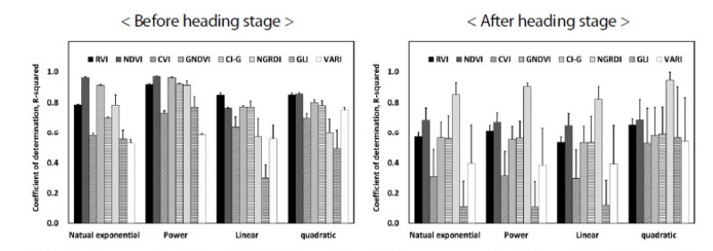
RVI (Ratio vegetation index), NDVI (Normalized difference vegetation index), CVI (Chlorophyll vegetation index), gNDVI (Greent normalized difference vegetation index, CI-G (Chlorophyll Index- Geen), NGRDI (Normalized green red difference index), GLI (Green leaf index), VARI (Visible atmospherically resistant index).
Relationship between vegetation indices and rice growth parameter (LAI).
- Publisher :Korean Society of Soil Science and Fertilizer
- Publisher(Ko) :한국토양비료학회
- Journal Title :Korean Journal of Soil Science and Fertilizer
- Journal Title(Ko) :한국토양비료학회 학회지
- Volume : 50
- No :5
- Pages :409-421
- Received Date : 2017-07-02
- Revised Date : 2017-10-18
- Accepted Date : 2017-11-04
- DOI :https://doi.org/10.7745/KJSSF.2017.50.5.409
 Korean Journal of Soil Science and Fertilizer