Quantification of Drainage Classes of Korean Soils as Morphological Characteristics
ABSTRACT
Introduction
Materials and Methods
Results and Discussion
극히양호, 매우양호, 양호
약간양호
약간불량, 불량, 매우불량, 극히불량
Conclusions
Introduction
토양분류는 기후, 식생, 모재료 등 토양의 생성요인에 기초를 둔 생성론적 분류와 토양 자체의 성질과 형태적인 특징에 기초를 둔 형태론적인 분류로 대분된다. 세계적으로 토양의 분류는 USDA의 Soil Taxonomy (ST)와 FAO의 World Reference Base for Soil Resources (WRB)가 가장 많이 활용되고 있으며, 우리나라는 주로 ST 방법을 따르고 있다.
한편, 각 나라별로 자국의 특성에 따라 별도의 분류체계를 가지고 있는 나라가 많으며 이들을 표준화하기 위한 작업들을 수행하고 있다. 아직도 표준화된 작업은 결실을 보지 못하고 있는 국가에서는 ST나 WRB를 표준분류법으로 많은 나라들이 채택하고 있는 상황이다. 표준화는 아직 이루어지지 않았지만 토양의 분류는 그 토양의 특성을 명확히 하고 토양들 간의 비교를 가능하게 하여 다양한 토양들을 여러 가지 조합에 의해 해설을 수행하고 있으며 (Hyeon et al., 1994; Jung et al., 1994, 1996; 2001; Sonn et al., 2018) 결국에는 인간이 이용 또는 관리하는데 도움을 주는 것을 목적으로 하고 있다 (Jung, 1996; NIAST, 1973; USDA, 2017).
토양의 특성은 물리적, 화학적, 점토광물학적, 기상학적, 형태학적인 특성들로 매우 다양하다. 현지에서 육안관찰에 의한 토양조사시 형태적인 특성들을 조사하게 되는데 배수등급, 지형, 자갈함량, 유효토심 등 작물재배와 밀접한 요인들이다. 이 요인들은 경험적인 지식을 바탕으로 하여 조사를 수행하여 왔으며 초보자나 토양을 처음 조사하는 사람들은 이해하기가 매우 어려운 항목들이다.
토양의 배수는 유거 (Runoff), 토양의 투수성 (Soil permeability), 내부 토양배수 (Internal soil drainage), 토양배수등급 (Soil drainage classes)으로 구별한다. 이러한 특성 중 가장 중요한 것은 배수등급이며, 이는 투수 (Percolation) 뿐만 아니라 지형에 따라서 유거에 의해 영향을 많이 받기도 한다.
우리나라의 농경지 중 논은 그 자체만 보면 평탄지로 되어 있고 대기중에서 토양으로 물이 하향의 방향으로 흐르는 투수 (Percolation) 이외에도 토양내에서 수직으로의 배수, 옆으로의 흐름 (Seepage) 등 다양한 요인들에 의해 색깔이 토괴의 표면으로 나타나게 된다. 농경지에서는 토성이나 기타 다른 특성들보다 배수등급이 생산력에 매우 큰 영향을 끼치게 되며, 또한 경사지의 농경지에서는 침투 등의 특성보다 경사에 의한 유거가 배수등급을 결정하는 요인이 된다.
배수등급은 유거, 내부 토양배수 및 투수성에 기초하여 광의로 규정하고 그 다음 토색 (Soil color), 반문의 양 (Mottle quantity), 반문의 존재부위 (Mottle position), 지하수위 (Ground water level), 토성 (Soil texture), 모재 (Parent material) 및 지형 (Topography)과의 관계를 규정하고 작물의 생산과의 관계를 두고 결정한다 (USDA, 2014, 2017). 이러한 인자들은 조사현장에서 조사자의 관측이나 판단에 근거하여 평가되기 때문에 수년의 훈련을 통해 숙련된 사람이 아니면 조사하기 어려울 뿐만 아니라 조사자의 주관적 영향을 완전히 배제하기 어렵다. 토양조사전문가가 감소하는 현실에서 초보자나 토양 조사 비숙련자도 배수등급에 대해 조사하고 이해할 수 있도록 하기 위해서는 객관적이고 정량적인 지표를 최대한 활용하는 것이 필요하다. 이에 본 논문에서는 배수등급을 계량적으로 접근하여 설정하고자 하였다.
Materials and Methods
우리나라의 전체 토양통 405개 중 임지토양을 제외하고 논토양 161개, 밭토양 144개로 총 305개의 농경지 토양통에 대하여 반문, 지하수위, 토색 (색상, 명도, 채도) 등을 조사·정리하였다. 배수등급은 극히양호 (Excessively drained), 매우양호 (Somewhat excessively drained), 양호 (Well drained), 약간양호 (Moderately well drained), 약간불량 (Somewhat poorly drained), 불량 (Poorly drained), 매우불량 (Very poorly drained), 극히불량 (Subaqueous)으로 구별한다. 그 기준은 Table 1과 같다.
Table 1을 보면 배수 극히양호에서 물이 매우 쉽게 제거된다라고 되어 있어 정의가 명확하지 않다. 매우양호 역시 양호와 구별되는 뚜렷한 말이 없어 정의를 계량화할 때는 양호로 정의할 수밖에 없게 된다. 이에 본 연구에서는 다음과 같은 인자를 활용하여 배수등급을 표현하고자 하였다: ⅰ) 토색 (색상, 명도, 채도), 암석에 의한 색, 산화환원에 의한 색, ⅱ) 주토색과 반문 (환원에 의한 색)이 있을 경우 산화환원에 의한 색은 그 양과 정도, ⅲ) 지하수위가 존재할 경우에는 그 깊이와 반문 (산화에 의한 색)의 양으로 구별하여 그 기준을 계량화하였다.
Table 1.
Criteria for Soil drainage class.
|
Classes
|
Morphological Characteristics
|
|
Excessively drained
|
Water is removed very rapidly. Internal free water occurrence commonly is very rare or very deep.
The soils are commonly coarse textured and have very high saturated hydraulic conductivity or are
very shallow.
|
|
Somewhat excessively drained
|
Water is removed from the soil rapidly. Internal free water occurrence commonly is very rare or
very deep. The soils are commonly coarse textured and have high saturated hydraulic conductivity
or are very shallow
|
|
Well drained
|
Water is removed from the soil readily but not rapidly. Internal free water occurrence commonly is
deep or very deep; annual duration is not specified. Water is available to plants throughout most of
the growing season in humid regions. Wetness does not inhibit root growth for significant periods
during most growing seasons. The soils are mainly free of, or are deep or very deep to, redoximorphic
features related to wetness
|
|
Moderately well drained
|
Water is removed from the soil somewhat slowly during some periods of the year. Internal free
water occurrence is commonly moderately deep and transitory through permanent. The soils are
wet for only a short time within the rooting depth during the growing season but long enough that
most mesophytic crops are affected. They commonly have a moderately low or lower saturated
hydraulic conductivity in a layer within the upper 1 meter, periodically receive high rainfall, or both
|
|
Somewhat poorly drained
|
Water is removed slowly so that the soil is wet at a shallow depth for significant periods during the
growing season. Internal free water occurrence is commonly shallow to moderately deep and
transitory to permanent. Wetness markedly restricts the growth of mesophytic crops, unless artificial
drainage is provided. The soils commonly have one or more of the following characteristics: low
or very low saturated hydraulic conductivity, a high water table, additional water from seepage, or
nearly continuous rainfall
|
|
Poorly drained
|
Water is removed so slowly that the soil is wet at shallow depths periodically during the growing
season or remains wet for long periods. Internal free water occurrence is shallow or very shallow
and common or persistent. Free water is commonly at or near the surface long enough during the
growing season that most mesophytic crops cannot be grown, unless the soil is artificially drained.
The soil, however, is not continuously wet directly below plow depth. Free water at shallow depth
is common. The water table is commonly the result of low or very low saturated hydraulic conductivity,
nearly continuous rainfall, or a combination of these
|
|
Very poorly drained
|
Water is removed from the soil so slowly that free water remains at or very near the surface during
much of the growing season. Internal free water occurrence is very shallow and persistent or
permanent. Unless the soil is artificially drained, most mesophytic crops cannot be grown. The
soils are commonly level or depressed and frequently ponded. In areas where rainfall is high or
nearly continuous, slope gradients may be greater
|
|
Subaqueous
|
Free water is above the soil surface. Internal free water occurrence is permanent, and there is a
positive water potential at the soil surface for more than 21 hours of each day. The soils have a
peraquic soil moisture regime.
|
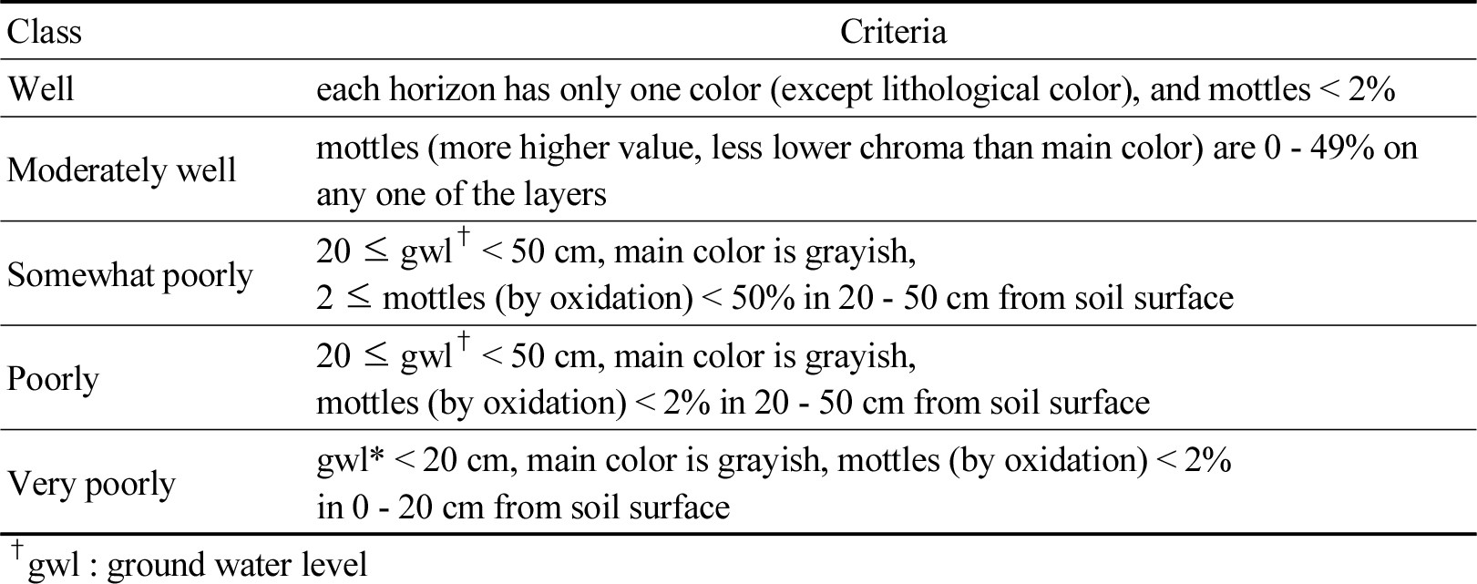
Table 2에는 지하수위의 기준을 50 cm로 하였는데, 이는 토양의 적성등급을 결정할 때 배수등급이 상부와 하부가 다를 경우 일반적으로 농경지에서 상부에 우선하여 결정하므로 50 cm의 기준이 중요하다. 또한 20 cm의 기준은 0 - 20 cm는 작토층에 해당하여 물이 차 있는 개념으로 보고 있어 중요하다.
Table 2.
Criteria for determining the drainage class.
|
Class
|
Criteria
|
|
Well
|
each horizon has only one color (except lithological color), and mottles < 2%
|
|
Moderately well
|
mottles (more higher value, less lower chroma than main color) are 0 - 49% on any one of the
layers
|
|
Somewhat poorly
|
20 ≤ gwl† < 50 cm, main color is grayish,
2 ≤ mottles (by oxidation) < 50% in 20 - 50 cm from soil surface
|
|
Poorly
|
20 ≤ gwl† < 50 cm, main color is grayish,
mottles (by oxidation) < 2% in 20 - 50 cm from soil surface
|
|
Very poorly
|
gwl† < 20 cm, main color is grayish,
mottles (by oxidation) < 2% in 0 - 20 cm from soil surface
|
Results and Discussion
극히양호, 매우양호, 양호
기존의 분류에 의하면 배수등급이 극히양호 (Excessively drained), 매우양호 (Somewhat excessively drained)와 양호 (Well drained)인 토양이 이에 해당한다. 본 논문에서는 임지토양 (100 토양통)을 제외하고 305개의 농경지 토양통에 대해서만 다루었다. 임지토양은 대부분이 극히양호 내지 매우양호로 분류되며 극히양호는 “물이 매우 빠르게 제거된다”, 매우양호는 “물이 빠르게 제거된다”, 양호는 “빠르지는 않고 쉽게 제거된다”로 구분하고 있어 유거에 의해 물이 제거되지만 이는 토양조사자료를 보더라도 경사에 의해서도 구분되지 않고 매우 막연한 말로 되어 있다. 우리나라는 극히양호와 매우양호인 토양을 매우양호로 취급하고 있다. 매우양호와 양호인 토양 배수등급은 토양의 단면을 보았을 때 각각의 층위별로 한가지의 색깔 (반문이 2% 미만)만을 가지고 있는 토양들로 정의할 수 있다. 물론 암석 자체가 여러 가지 색을 띠고 있는 경우는 풍화되어도 자체의 색들을 가지고 있어 모암에 의한 색깔은 잘 구별하여 반문에 포함시키지 않는다. 이들 토양들은 양호 (Well drained)로 분류되어지며 그 기준은 Table 2에 나타나 있고 이에 따른 토양통은 모암 (모재)지대별로 Table 3에 나타나 있다.
Table 3을 보면 화강암 및 화강편마암 지대의 토계, 입석, 홍천통은 매우양호로 되어 있으나 단면의 색으로 판단할 때 양호와 구별할 수가 없으며, 하성평탄지의 화봉, 낙동, 황룡통, 하해혼성평탄지의 비천, 해리, 대본, 일평통 등 역시 양호로 처리하는 것이 무방하다. 이 토양통들은 경사가 거의 없는 평탄지에 분포하며 육안으로 볼 때 사질계 토양으로 투수가 빠르기는 하지만 배수등급을 논할 때 기준은 없는 농경지 토양들이다.
Table 3.
Soil series with “Well” drainage class.
|
Parent material
|
Soil Series
|
No.
|
|
Highland
|
Imog, Mui, Chugye, Unbong, Sinbul, Ungyo
|
6
|
|
Granite & Granite Gneiss
|
Togye, Ibseog, Hongcheon† |
3
|
Sangju, Seongsan, Iwon, Gwacheon, Pungcheon, Deoggye, Baegsan, Wongog,
Anryong, Jeongeub, Yonggye, Seogto, Hogye, Agyang, Bansan, Gaghwa
|
16
|
|
Ryolite
|
Hwasun, Ungog
|
2
|
|
Porphyry
|
Goheung
|
1
|
|
Anorthite
|
Galjeon
|
1
|
|
Tirtiary
|
Bangog
|
1
|
|
Limestone
|
Anmi, Yeongwol, Dojeon, Maji, Pyeongjeon, Uji, Pyeongan, Mitan
|
8
|
|
Grayshale
|
Banho, Dogye
|
2
|
|
Redshale
|
Imdong, Gamgog, Jincheon
|
3
|
|
Sandstone
|
Danbug, Dain
|
2
|
|
Conglomerate
|
Jugog
|
1
|
|
Gneiss & Schist
|
Jigog, Suam, Ugog, Daeheung
|
4
|
|
Phyllite
|
Heugseog, Chojeong, Jecheon, Namgog
|
4
|
|
Quartzite
|
Nogjeon
|
1
|
|
Diluvium
|
Imja, Nonsan, Jangho, Bancheon, Chundo, Gopyeong, Wangsan, Cheongpung,
Gwangju, Changpyeong
|
10
|
|
River plain
|
Hwabong, Nagdong, Hwangryong‡ |
3
|
|
Jungdong, Bonryang, Deogcheon, Ryucheon, Ihyeon
|
5
|
|
Fluvio-Marine
|
Bicheon, Haeri, Daebon, Ilpyeong§ |
4
|
|
Bugpyeong, Yeondae
|
2
|
|
Ulreung
|
Jugam, Albong, Namyang, Dodong, Hongmun, Jeodong, Nari
|
7
|
|
Lava terrace (except Jeju)
|
Jangpa
|
1
|
|
Jeju
|
Namwon, Wuimi, Sineom, Jeongbang, Euigui, Andeog, Topyeong, Jeju, Ora, Jungeom,
Daepyeong, Gyorae, Songdang, Pyoseon, Hanrim, Ara, Weolryeong, Daeheul, Sara,
Donggui, Gueom, Ido, Udo, Yongheung, Hawon, Mureung, Yeongrag, Hamo, Inseong,
Bongseong, Hoisu, Nogjeon, Nogsan, Gueom
|
34
|
|
Man-Made
|
Doam
|
1
|
|
Sum
| |
122
|
약간양호
이 토양은 배수등급이 약간양호 (Moderately well drained)인 토양이 해당된다. 약간양호인 토양은 지하수위가 없거나 2 m이상으로 매우 깊으며, 환원을 약간 받은 토양을 말한다. 주토색이 갈색, 황색, 적색 등을 띠며, 반문 (환원에 의한 반문)의 양은 50% 미만이며, 주토색보다 반문의 색이 명도 (value)는 높고 채도는 낮은 (chroma) 상태의 토양을 말한다. 밭토양이 약간양호인 것은 주로 볼록 (凸)한 형태로 되어 있고 산록경사지 및 곡간·선상지에 분포하며 습해의 발생이 우려되는 토양이며 이에 따른 토양통은 모암 (모재)지대별로 Table 4-1에 나타나 있고 논토양이 약간양호인 것은 역시 볼록 (凸)한 형태로 되어 있으며 이에 따른 토양통은 모암 (모재)지대별로 Table 4-2에 나타나 있다. 약간양호의 육안판별 기준은 Table 2에 나타나 있으며 주토색과 비교하여 반문의 색이 명도는 높고 채도는 낮은 상태이고 반문의 양은 50% 미만인 상태를 말한다.
Table 4-1.
Soil series with “Moderately well” drainage class (Upland).
|
Parent material
|
Soil Series
|
No.
|
|
Granite & Granite Gneiss
|
Noegog, Galgog, Daegog, Bugog, Jangwon, Weonji, Yeongog, Pogog
|
8
|
|
Grayshale
|
Yuhyeon
|
1
|
|
Gneiss & Schist
|
Changgog
|
1
|
|
Diluvium
|
Gongseong, Upyeong, Gangreung
|
3
|
|
River plain
|
Docheon, Jucheon, Yuwon, Byeompyeong
|
4
|
|
Fluvio-Marine
|
Myeongji, Hasa
|
2
|
|
Jeju
|
Yongdang, Aewol, Gangjeong
|
3
|
|
Sum
| |
22
|
Table 4-2.
Soil series with “Moderately well” drainage class (Paddy).
|
Parent material
|
Soil Series
|
No.
|
|
Highland
|
Janggye, Sangye, Abgog, Cheonpyeong, Inje, Daewon
|
6
|
|
Granite & Granite Gneiss
|
Haggog, Eungog, Yongji, Chilgog, Hampyeong, Geumgog, Haenggog, Chogye
|
8
|
|
Porphyry
|
Pangog, Gangjin
|
2
|
|
Anorthite
|
Ogdong, Teuggog
|
2
|
|
Tirtiary
|
Cheonggye
|
1
|
|
Limestone
|
Yulgog, Oggye, Gugog
|
3
|
|
Grayshale
|
Bigog, Deoggog, Gyeongsan
|
3
|
|
Redshale
|
Maryeong, Samam, Juggog
|
3
|
|
Sandstone
|
Yonggog, Dongam, Angye
|
3
|
|
Conglomerate
|
Magog
|
1
|
|
Gneiss & Schist
|
Bognae, Maegog, Weolgog
|
3
|
|
Phyllite
|
Jinmog, Banggog
|
2
|
|
Diluvium
|
Jangyu, Hwadong, Deogpyeong, Geugrag, Banggi
|
5
|
|
River plain
|
Geumcheon, Jangcheon, Namgye, Gangseo, Gocheon, Opyeong, Chilwon, Hagsan,
Tongcheon, Ocheon, Cheongwon, Simcheon, Gyuam
|
13
|
|
Fluvio-Marine
|
Baegsu, Sadu
|
2
|
|
Ulreung
|
Cheonbu
|
1
|
|
Lava terrace (except Jeju)
|
Paju, Dongsong
|
2
|
|
Jeju
|
Yonggang, Daejeong, Yongsu
|
3
|
|
Man-Made
|
Insang, Insaeng, Ingwan, Inga, Ingog, Inji, Inweol
|
7
|
|
Sum
| |
70
|
약간불량, 불량, 매우불량, 극히불량
이 토양은 배수등급이 약간불량 (Somewhat poorly drained), 불량 (Poorly drained), 매우불량 (Very poorly drained), 극히불량 (Subaqueous)인 토양이 해당된다. 농경지 토양에서는 약 1m정도를 기준으로 하여 토양의 상태를 결정하는데 상하부를 표현할 때 50 - 60 cm를 기준하며, 상부와 하부의 특성이 다를 때, 작물 재배를 할 경우 특히 상부 50 cm의 상태가 중요하다. 이 토양들은 모두 지하수위가 매우 높으며, 약간불량과 불량은 지하수위가 20 - 50 cm이내에 분포하며 그 아래에는 주토색이 회색계이고 반문 (산화에 의한 반문)의 양이 약간불량은 2 - 50%, 불량은 0 - 2%를 보인다. 매우불량과 극히불량은 0 - 20 cm에 분포하며 주토색이 회색계이고 반문 (산화에 의한 반문)의 양이 0 - 2%를 보인다. 극히불량이 매우불량과 다른 점은 표면까지 물로 포화되어 있는 상태를 말한다. 주로 습지 등이 극히불량에 해당하나 우리나라의 농경지는 극히불량이 없으며 습지가 많지 않아 매우불량과 극히불량은 매우불량 하나로 보아도 무방하다. Soil Taxonomy와 World Reference Base for Soil Resource는 배수등급에서 많은 차이를 보이며 (FAO, 2006, 2014; USDA, 2012; Sonn et al., 2019) 조사방법이 ST에서는 ‘g’만으로 구별하고 있고 WRB에서는 ‘r’과 ‘l’을 사용하여 그 표현을 달리하고 있다 (Sonn et al., 2019). 그 기준은 Table 2에 나타나 있고 이에 따른 토양통은 모암 (모재)지대별로 Table 5에 나타나 있다. 배수등급에 대한 모식도는 Fig. 1과 같다.
Table 5.
Soil series with “Somewhat poorly” drainage class.
|
Parent material
|
Soil Series
|
No.
|
|
Highland
|
Agog
|
1
|
|
Granite & Granite Gneiss
|
Sachon, Subug, Jisan, Hyocheon
|
4
|
|
Rhyolite
|
Dogog
|
1
|
|
Porphyry
|
Jindo, Gagog
|
2
|
|
Anorthite
|
Geumseo
|
1
|
|
Tirtiary
|
Yugye
|
1
|
|
Limestone
|
Mungyeong
|
1
|
|
Grayshale
|
Yuga, Yugog
|
2
|
|
Redshale
|
Bonggog
|
1
|
|
Sandstone
|
Jeomgog, Yanggog
|
2
|
|
Gneiss & Schist
|
Gamcheon, Hoegog, Imgog
|
3
|
|
Phyllite
|
Jonggog, Yegog
|
2
|
|
River plain
|
Seogcheon, Seoggye, Gacheon, Nampyeong, Mulgeum, Sinheung, Manseong,
Yeongsan, Pyeongtaeg, Miwon, Honam
|
11
|
|
Fluvio-Marine
|
Hagpo, Gwangpo, Taean, Pyeonghae, Seungju, Yulpo, Mangyeong, Hyangho,
Jeonbug, Deogha, Deunggu, Gimhae, Daldong, Chunpo, Buyong, Gimje, Bongnam
|
17
|
|
Lava terrace (except Jeju)
|
Yeoncheon, Cheolwon
|
2
|
|
Jeju
|
Weolpyeong, Haean
|
2
|
|
Man-Made
|
Indong
|
1
|
|
Sum
| |
54
|
Table 6.
Soil series with “Poorly” drainage class.
|
Parent material
|
Soil Series
|
No.
|
|
Granite & Granite Gneiss
|
Baeggu
|
1
|
|
River plain
|
Hwasu, Sugye, Sinpyeong
|
3
|
|
Fluvio-Marine
|
Geumjin, Gupo, Dapyeong, Gwanghwal, Bogcheon, Podu, Bongrim, Hagseong, Yeosu,
Seotan, Pori, Haecheog
|
12
|
|
Jeju
|
Nagcheon, Iho
|
2
|
|
Man-Made
|
Inog, Inchang
|
2
|
|
Sum
| |
20
|
Table 7.
Soil series with “Very poorly” drainage class.
|
Parent material
|
Soil Series
|
No.
|
|
Granite & Granite Gneiss
|
Yecheon, Ogcheon, Gangdong
|
3
|
|
Grayshale
|
Goryeong
|
1
|
|
Gneiss & Schist
|
Chuncheon
|
1
|
|
River plain
|
Sindab, Geumji, Hamchang, Icheon, Heungpyeong
|
5
|
|
Fluvio-Marine
|
Yeompo, Munpo, Dongho, Gapo, Poseung, Yongho, Gongdeog
|
7
|
|
Sum
| |
17
|
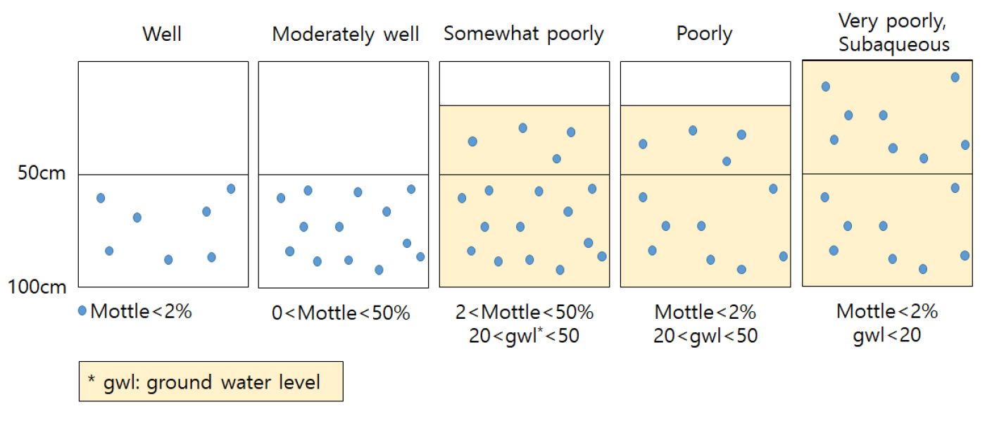
Fig. 1
Schematic diagram of drainage classes.
Conclusions
토양의 특성들은 형태적인 특성들이 매우 중요하며, 이들 중 배수등급은 토양의 산화환원상태를 나타내주는 지표이며 토색에 의해 결정되어진다. 토색은 문셀 토색첩을 이용하여 측정하며 측정하는 사람마다 약간씩 오차가 생길 수도 있으나 그동안 계량화가 안 되어 있어 일반 토양학자들의 접근이 어려운 현실이었다. 토양조사를 수행하는 사람들은 머릿속으로만 기억하고 있어 다른 사람들한테 정성적인 부분을 설명하기 어려운 점이 있다. 이들의 계량화는 매우 중요하며 토양 형태적 특성의 중요한 요인인 배수등급을 계량화함으로서 많은 토양학자들이 쉽게 접근할 수 있다. 배수등급의 계량화에는 ⅰ) 토색 (색상, 명도, 채도), 암석에 의한 색, 산화환원에 의한 색이 중요한 요인이 되며, ⅱ) 주토색과 반문 (환원에 의한 색)이 있을 경우 산화환원에 의한 색은 그 양과 정도가 중요하고, ⅲ) 지하수위가 존재할 경우에는 그 깊이와 반문 (산화에 의한 색)의 양이 중요한 결정요인이 된다. 더 나아가 배수등급 뿐만 아니라 다른 특성들까지도 계량화하여 우리나라의 특성에 맞는 자체적인 분류체계를 만들어야 할 것이다.
Acknowledgements
This work was supported by the “Cooperative Research Program for Agriculture Science & Technology Development (Project No. PJ015074),” Rural Development Administration, Republic of Korea.
References
Field Book for Describing and Sampling Soils. 2012. Ver. 3.0. USDA-NRCS. pp.2-18.
Field soil survey handbook. 2018. NAS. RDA.
Guidelines for Soil Description. 2006. Fourth Edition. FAO.
Hyeon, G.S., C.S. Park, S.J. Jung, S.K. Rim, and Y.K. Jo. 1994. Land Suitability Classification for Grape Orchards in Korea. Res. Rept. RDA(S&F). 36(2):246-250.
Jung, Y.T. 1996. Application of Soil Taxonomy: Advantage and Disadvantage of American Soil Taxonomy. Korean J. Soil Sci. Fert. 29(2):207-210.
Jung, Y.T., I.S. Son, E.S. Yun, J.K. Kim, S.J. Jung, and G.H. Cho. 1994. A Study on the Establishment of Land Suitability Grouping for Paddy-upland Rotation System in Korea. Res. Rept. RDA(S&F). 36(2):262-267.
Jung, Y.T., I.S. Son, E.S. Yun, Y.K. Sonn, and Y.P. No. 1996. Tentative Suitability Criteria for the Consolidation of Cultivated Upland in Korea. J. Korean Soc. Soil Sci. Fert. 29(2):81-85.
Jung, Y.T., S.J. Jung, G.S. Hyeon, Y.K. Sonn, Y.K. Cho, E.S. Yun, and G.H. Cho. 2001. Classification of Morphological types of the Korean Paddy Soils for Practical Use of Soil Survey Results. J. Korean Soc. Soil Sci. Fert. 34(2):77-84.
Keys to Soil Taxonomy. 2014. Twelfth Edition. USDA. pp.335-340.
Soil Survey Manual. 1973. Field Investigation and Classification. No. 1. NIAST, RDA.
Soil Survey Manual. 2017. Soil Science Division Staff. Agriculture Handbook No. 18. USDA. pp.151-152.
Sonn, Y.K., B.H. Seo, W.R. Go, S.H. Jeon, B.K. Hyun, and S.G. Yun. 2019. Consideration of Suffix Symbol on Soil Taxonomy and World Reference Base for Soil Resources Classification. Korean J. Soil Sci. Fert. 52(4):345-351.
Sonn, Y.K., W.R. Go., S.H. Jeon, B.K. Hyun, M.S. Im, and S.G. Yun. 2018. The Use of Useful Statistics of Soil Texture According to Standardized Depth Between Two Digital Soil Maps. Korean J. Soil Sci. Fert. 29(2):564-575.
World Reference Base for Soil Resources. 2014. FAO.