

Introduction
Materials and methods
Study site description
Land preparation, treatments and cropping system management
Field monitoring and data collection
Estimating cover management factors
Statistical analysis
Results and Discussion
Rainfall amounts and intensities during cultivation
Runoff and soil loss trends in potato cultivated lysimeters
Runoff and soil loss trends in bare lysimeters
Runoff and soil losses across slope gradients, cultivation types and years
Impact of cultivation type on runoff and soil loss
Effect of slope on runoff and soil loss
Cover management factor of conventionally cultivated potato
Conclusion
Introduction
Soil loss is one of the most pressing environmental challenges facing highland agriculture, particularly in intensively cultivated regions such as the Gangwon Province, South Korea (Lee et al., 2010; Kim et al., 2023). The province is a critical agricultural region known for its mountainous terrain and significant production of potato (Solanum tuberosum L.). There is widespread cultivation of potato in the highlands, due to favourable climatic conditions. However, cultivation on steep slopes, minimal vegetative cover and agronomic practices including: frequent tillage and ridge making, makes potato cultivation a key driver of soil erosion and loss (Arifin et al., 2021). Soil loss in these highland systems is exercabated by susceptible soil textures (such as loamy sands in our slope lysimeters) and intense seasonal rainfall, particularly during Korea’s monsoon period, which leads to increased surface runoff and sediment transport (Fullen et al, 1997; Guduru and Jilo, 2022). In conventional potato production, ridging and row spacing create micro-topographical variations which when combined with bare soil conditions during early growth stages, further increase erosion susceptibility. Studies have shown that soil loss from tilled sloping lands in Korea can exceed tolerable limits, sometimes reaching values over 30 Mg ha-1 year-1 (Jang et al., 2015). Yet, despite the environmental risks, quantitative and site-specific data on soil loss under potato-based systems in Gangwon highlands remain limited.
Inadequate soil loss information leads to limited targeted soil conservation proactivity, posing a long-term threat to soil fertility, water quality and agricultural productivity in the region. Without intervention, continued soil degradation could compromise both ecosystem services and farmer livelihoods. Addressing this issue is particularly urgent in light of climate change, which is expected to increase the frequency and intensity of extreme rainfall events, thereby intensifying soil erosion and loss processes (IPCC, 2021). Moreover, the downstream effects of sedimentation such as eutrophication and infrastructure damage points out to broader environmental consequences of unchecked soil losses from top slopes.
This study aims to evaluate the extent and drivers of soil loss under conventional potato cultivation in highland agriculture in the Gangwon Province. Using a field-based soil collection slope lysimter set-up, the research quantifies soil loss under different slope gradients across three different years on loamy sand soil textures. It also assesses the effectiveness of potato vegetative cover in controlling soil loss in conventionally tilled soil using cover management factor (C-factor) calculations. The C-factor represents the impact of vegetation cover on soil loss, expressed as a ratio relative to soil loss on conventionally tilled, continuously bare land (Xiong et al., 2023; Brempong et al., 2024). It ranges from 0 to 1, where 0 corresponds to complete soil protection with no loss, and 1 represents the maximum soil loss observed on clean-tilled bare soil. The study hypothesizes that conventionally cultivated potato lysimeters will record substantial soil losses (C-factors approaching 1) due to the intense soil disturbance involved in land preparation and sparse potato vegetation. Moreover, the loamy sand soils in our slope lysimeters are likely to experience considerable losses at higher gradients, as erosion rates of loamy sands increase with slope steepness (Fullen et al., 1997). By generating localized data, this research provides critical insight for the design and implementation of sustainable land management strategies tailored to potato production in Korea’s highland agriculture. Ultimately, the findings are expected to support policy recommendations, inform farmer training programs and guide investment in climate-resilient farming practices. It contributes to broader national and international goals of reducing land degradation, enhancing soil health and promoting sustainable food production in vulnerable agroecosystems.
Materials and methods
Study site description
Three experiments were conducted in 2021, 2023, and 2024 using slope lysimeters with gradients of 2%, 7%, and 15% at the Highland Agriculture Research Institute, Daegwallyeong, Pyeongchang-gun, Gangwon-do, South Korea (37°40'48.0''N, 128°43'51.0''E). The lysimeters were constructed in accordance with the Universal Soil Loss Equation (USLE) guidelines set by the U.S. Department of Agriculture (USDA). Each lysimeter measured 2.8 m in width and 22.4 m in length, and was filled with saprolite; soil derived from chemically weathered rock, with a loamy sand texture (Sand - 80%; Silt - 17% ; Clay - 3%) and bulk density of 1.29 Mg m-3. On average, the soils have -2.6% organic matter. The total annual rainfall recorded during the respective experimental years was 1,027 mm (2021), 680 mm (2023), and 1,170 mm (2024). Rainfall and temperature data were obtained from the Korean Government Weather Station located in Daegwallyeong, Pyeongchang-gun, Gangwon-do.
Land preparation, treatments and cropping system management
The experiments were conducted in slope lysimeters with gradients of 2%, 7%, and 15% during the 2021, 2023 and 2024 potato growing seasons, respectively. Due to limited number of lysimeters, the experiments were not replicated in any of the years. Cultivation periods were from May 9 to September 10, 2021; May 14 to September 19, 2023; and May 9 to August 23, 2024. Prior to cultivation, the lysimeters were conventionally tilled, and ridges approximately 45 cm wide were formed longitudinally along the slope. The uncultivated bare lysimeters were also conventionally tilled but left bare throughout the experimental period. Cultivated lysimeters received 3.8 Mg ha-1 of mixed livestock compost applied three weeks before planting, based on the standard compost recommendation for highland potato production by the National Institute of Agricultural Sciences (NIAS, 2022). In addition, a single application of mineral fertilizer (N:P:K at 137:33:114 kg ha-1), recommended by NIAS (2022), was applied one week before planting sprouted seed potato. The study involved two treatments namely: conventionally cultivated potato lysimeters during the growing season, and bare lysimeters (hereafter called bare land) throughout the same period. All experiments were conducted under rainfed conditions. Weed control was maintained using herbicides. In the bare lysimeters, herbicides were applied periodically to prevent any vegetation growth. In the cultivated plots, herbicides were used to manage weed emergence during the growing season.
Field monitoring and data collection
Soil loss and runoff were measured during rainfall events. A rainfall event was defined as a single rainfall occurrence, or a series of rainfall sessions separated by no more than six hours, that produced a cumulative rainfall amount of 12.7 mm or more, following the modified definition by Wischmeier and Smith (1978). During each event, hourly rainfall amounts were recorded using 300 L collection tanks installed in the water collection units of the lysimeters. Runoff, consisting of rainwater mixed with eroded soil, flowed through a splitter mechanism that separated a representative subsample at a fixed ratio of 1:100 (runoff to collected sample). The splitter operated automatically by gravitational force. Rainfall data were recorded using the ATMOS 41 weather sensor connected to a ZL6 datalogger, both installed within the runoff collection system. Rainfall erosivity (EI30, MJ mm ha-1 hr-1) was calculated using the method proposed by Foster et al. (1981). It should be noted that soil loss and runoff data collected on 06.24.2024 is from rainfall events on 06.22.2024 and 06.24.2024. Some of the soil loss and runoff data were collected a day or two after the rainfall event especially if it fell on a weekend.
Estimating cover management factors
Cover management factors of potato were calculated by the following equation (adapted from NIAST, 2012).
where, Σ means summation, Aci is the soil loss from the plant/residue cover on a certain date, Ai is the soil loss under the bare soil on that same date.
Statistical analysis
Collected datasets were subjected to regression and correlation analyses using Microsoft Excel. Data from the three experimental years (2021, 2023, and 2024) were combined for the regression analysis. Soil loss was regressed against rainfall intensity and rainfall amount to evaluate their relationships using pooled data points from all three years. Additionally, total soil losses and runoff volumes in a lysimeter, under a cultivation type, in a year were cumulated. Averages of the cumulated values were calculated for year (2021, 2023, 2024), cultivation type (bare land or potato) and slope lysimeter (2, 7 and 15% slopes) using IBM SPSS Statistics version 20.
Results and Discussion
Rainfall amounts and intensities during cultivation
During the cultivation periods, the total rainfall amounts recorded on rainfall events were 534 mm in 2021, 729 mm in 2023, and 339 mm in 2024. Average rainfall intensities (EI30) corresponding to these periods were 86 MJ mm ha-1 hr-1, 105 MJ mm ha-1 hr-1, and 67 MJ mm ha-1 hr-1, respectively. Figure 1 presents the rainfall amounts and intensities recorded during individual rainfall events throughout the experimental periods.
Runoff and soil loss trends in potato cultivated lysimeters
Runoff volumes and rainfall intensity relationships
Total runoff volumes in potato lysimeters followed varying patterns across the three experimental years (Fig. 1). In 2021, runoff volumes followed the order: 7% slope (2,076 Mg ha-1) > 2% slope (1,283 Mg ha-1) > 15% slope (1,212 Mg ha-1). However, 2023 recorded the sequence: 2% (1,073 Mg ha-1) > 15% (1,054 Mg ha-1) > 7% (971 Mg ha-1), while in 2024, runoff volumes were relatively lower overall, with the pattern: 2% (515 Mg ha-1) > 15% (365 Mg ha-1) > 7% (338 Mg ha-1). Runoff patterns (Fig. 2) closely mirrored rainfall intensities (Fig. 1) across the study years, confirming that rainfall intensity is a major driver of runoff processes. This observation is supported by strong positive correlations (r ≈ 0.35 - 0.81) between rainfall intensity and runoff volume, as shown in Table 1. This is consistent with findings from previous studies, where rainfall intensity was identified as the primary factor influencing surface runoff generation, particularly in sloped agricultural systems (Buda et al., 2007; Zhao et al., 2013). In 2021, the highest peak runoff (780 Mg ha-1) occurred on September 2 in the 7% slope lysimeter, followed by another peak (-460 Mg ha-1) on July 5, also in the 7% slope lysimeter (Fig. 2). Both peaks aligned with peak rainfall intensities (Fig. 1), emphasizing the control of rainfall intensity on runoff volumes, as rainfall intensity governs the threshold behaviour of runoff initiation (Nanda and Safeeq, 2023). Contrary to our assumption, relatively lower runoff volumes were recorded in the 15% slope lysimter during these peak events, potentially due to better infiltration rates in the steeper slope lysimeter, as differences in soil hydrologic conditions such as soil structure, porosity, or compaction levels may exist among the lysimeters (Cantón et al., 2011). These findings suggests that runoff may not always increase linearly with slope gradient, as often assumed; instead, it is influenced by a combination of factors such as slope, rainfall characteristics, runoff energy and flow velocity and intrinsic soil physical properties (Kinnell, 2010; Li et al., 2017). According to Lee et al. (2025), differences in soil water content between flat and 5° (11%) sloped land under soybean cultivation were attributed to higher runoff on the slope. This indicates that slope effects on runoff are noticeable at gentle gradients, while other factors may dominate runoff generation at steeper slopes. In 2023, a major rainfall event on August 11 (combining high rainfall amount and intensity) triggered a runoff peak of 470 Mg ha-1 in the 7% slope, while the least runoff (below 300 Mg ha-1) was recorded in the 15% slope (Fig. 2), further confirming the complex interplay of hydrologic and soil factors. Slope steepness was observed to be weakly correlated with runoff volume across all three years (r ≈ 0.001 - 0.19), as shown in Table 1. In 2024, runoff volumes were significantly lower across all slope gradients (Fig. 2), corresponding with the lower rainfall totals and intensities observed that year (Fig. 1).
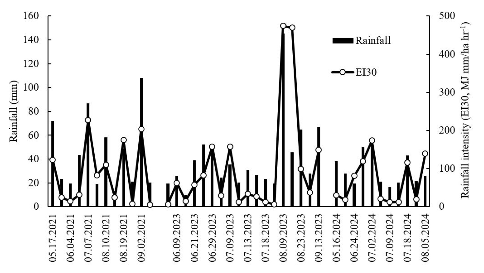
Fig. 1
Rainfall amount (mm) and rainfall intensity (MJ mm ha-1 hr-1) during the potato growing seasons in 2021, 2023, and 2024. The data represent event-based measurements collected over the cultivation periods each year, illustrating variations in both total precipitation and intensity of rainfall events across the three seasons.
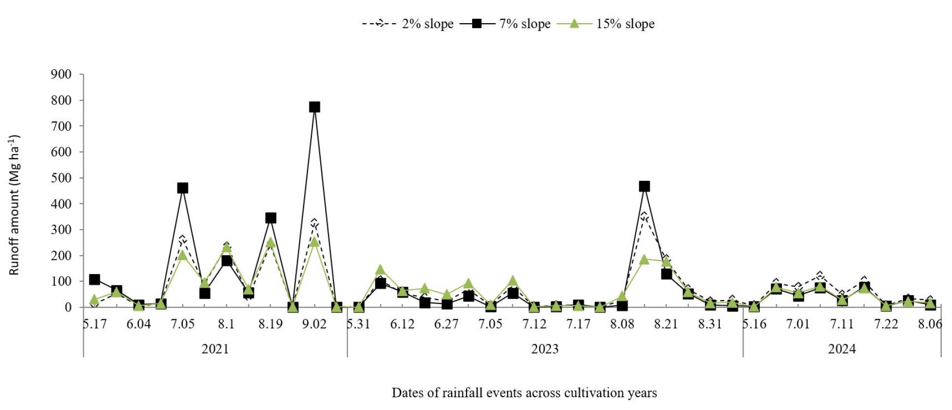
Fig. 2
Runoff amount (Mg ha-1) from potato lysimeters at 2%, 7%, and 15% slopes during the 2021, 2023, and 2024 cultivation seasons. The data illustrate temporal fluctuations in runoff associated with rainfall events, showing generally higher runoff at steeper slopes, particularly at 7% during peak rainfall events in 2021 and 2023. Runoff levels were relatively lower and more stable across all slopes in 2024 due to reduced rainfall.
Table 1
Correlation between soil loss, runoff, rainfall amount and rainfall intensity in potato cultivated lysimeters in 2021, 2023 and 2024.
Soil loss dynamics and slope influence
Cumulative soil loss under potato cultivation followed a consistent increasing trend with slope steepness across all years (Fig. 3). In 2021, soil loss ranked: 15% slope (15 Mg ha-1) > [2% slope (3 Mg ha-1) = 7% slope (3 Mg ha-1)]; in 2023: 15% slope (30 Mg ha-1) > 7% slope (6 Mg ha-1) > 2% slope (3 Mg ha-1); and in 2024: 15% slope (11 Mg ha-1) > 7% slope (4 Mg ha-1) > 2% slope (1 Mg ha-1). The 15% slope lysimeter recorded the highest soil loss on most sampling dates (Fig. 3), indicating a persistent effect of slope on erosion. This is consistent with Fullen et al. (1997), who found that loamy sand soils become increasingly erodible as slope steepness increases. Unlike runoff, soil loss (Fig. 3) did not strictly follow patterns in rainfall amount or intensity (Fig. 1), nor did it always align with peak runoff events (Fig. 2). Correlation analyses (Table 1) show that soil loss was more strongly correlated with slope gradient (r ≈ 0.32 - 0.43) than with rainfall intensity (r ≈ 0.04 - 0.08) or runoff volume (r ≈ 0.07 - 0.25), implying that gravity-driven sediment detachment and transport processes become more effective with increasing slope gradient (Lal, 1997; Wischmeier and Smith, 1978). Higher soil losses observed at the beginning of the growing seasons, especially in 2023 and 2024 (Fig. 3), when rainfall amounts and intensities were relatively low (Fig. 1), reflect a combination of the effects of physical soil disturbance from conventional tillage / ridging and reduced vegetation cover during these early periods, which left destabilized soil aggregates vulnerable to raindrop impact (Pulley and Collins, 2020; Morgan, 2005). Conventional tillage is known to disturb soil structure, break down soil aggregates and increase the soil’s susceptibility to erosion (Lal, 1998), making it more vulnerable to even-low intensity rainfall events. Lower soil losses even under peak runoff volumes, close to the end of the cultivation periods (Fig. 2) indicate that vegetative cover from potato crops may have mitigated soil loss, especially during late growing stages when canopy closure reduced raindrop impact and soil surface had crusted with time. This protective role of vegetation in reducing erosion is well-documented (Gyssels et al., 2005). It suggests that vegetative management is critical to erosion control, on steep agricultural slopes.
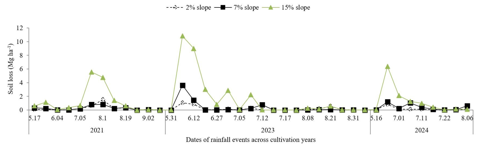
Fig. 3
Soil loss (Mg ha-1) from potato lysimeters at 2%, 7%, and 15% slopes during the 2021, 2023, and 2024 cultivation seasons. Soil loss consistently increased with slope gradient, with the highest values recorded at 15% slopes, particularly during major rainfall events in 2021 and 2023. Soil loss was minimal in 2024, due to lower rainfall intensity.
Runoff and soil loss trends in bare lysimeters
Runoff volumes and rainfall intensity relationships
Total runoff volumes in the bare lysimeters followed the order: 7% slope (1921 Mg ha-1) > 15% slope (1860 Mg ha-1) > 2% slope (1798 Mg ha-1) in 2021; 7% slope (3680 Mg ha-1) > 2% slope (3543 Mg ha-1) > 15% slope (3370 Mg ha-1) in 2023, and 15% slope (1345 Mg ha-1) > 7% slope (1242 Mg ha-1) > 2% slope (1218 Mg ha-1) in 2024 (Fig. 4). Runoff volumes in the slope lysimeters were variable across the three years (Fig. 4). Contrary to our assumption that steeper slopes would result in increasing runoff volumes, the results indicate that runoff volumes were not strongly related to slope gradients; further supported by weak correlations between slope and runoff volumes across the years (r ≈ 0.009 to 0.07) as shown in Table 2. These findings are consistent with previous studies by Fox and Bryan (2000) who reported that beyond a certain threshold, increases in slope do not necessarily translate to higher runoff, especially when other environmental and soil factors are at play. Similarly, Liu et al. (2019) reported that soil micro-topography, antecedent moisture and rainfall characteristics often override the effect of slope in runoff generation. As observed in the potato cultivated lysimeters, rainfall characteristics and differences in soil physical properties appear to play more dominant roles in determining runoff in the bare lysimeters. Runoff volumes across the years closely mirrored variations in rainfall amount and intensity. One notable event occurred on August 11 2023, when the highest rainfall intensity and amount recorded across all three years (Fig. 1) corresponded with the highest runoff volume (Fig. 4). Other smaller peaks in runoff volumes also aligned with peak rainfall events. The relationship is confirmed by strong correlations between runoff volumes and rainfall intensity (r ≈0.46 to 0.89), as well as amounts (r ≈ 0.44 to 0.92) across the years, as shown in Table 2. Previous studies have shown that rainfall amounts and intensities are primary drivers of runoff, especially in bare or minimally vegetated systems (Mishra and Singh, 2003; Deng et al., 2019). The year 2024 recorded relatively lower runoff volumes, because rainfall amounts and intensities were relatively lower across this year. This observation aligns with Kinnell et al. (2005) who found that inter-annual variation in rainfall patterns is the most influential factor determining runoff volumes in experimental settings.
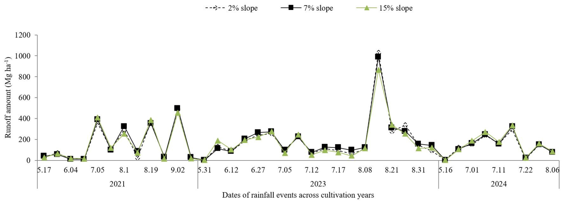
Fig. 4
Runoff dynamics (Mg ha-1) from bare lysimeters at 2%, 7%, and 15% slopes during the 2021, 2023, and 2024 cultivation seasons. Runoff volumes were strongly associated with rainfall amounts and intensities, with the highest peaks occurring during intense rainfall events, particularly in 2023. Slope gradients had a weaker influence compared to rainfall characteristics across the cultivation years.
Table 2
Correlation between soil loss, runoff, rainfall amount and rainfall intensity in bare lysimeters in 2021.
Soil loss dynamics with the influence of slope and rainfall parameters
Total soil losses in the bare lysimeters followed the order: 15% slope (146 Mg ha-1) > 7% slope (42 Mg ha-1) > 2% slope (4 Mg ha-1) in 2021; 15% slope (516 Mg ha-1) > 7% slope (109 Mg ha-1) > 2% (9 Mg ha-1) in 2023 and 15% slope (167 Mg ha-1) > 7% slope (21 Mg ha-1) > 2% slope (3 Mg ha-1) in 2024. Soil loss patterns mirrored those of runoff and rainfall intensity with erosion rates increasing substantially with slope gradient (Fig. 5). The 15% slope lysimeter recorded the highest soil losses which peaked at -110 Mg ha-1 on July 3 and 90 Mg ha-1 on August 21 in 2023, corresponding with various peak rainfall amounts and intensities in the season. The 7% slope recorded moderate losses, while the 2% slope remained relatively stable, with values rarely exceeding 10 Mg ha-1 across all seasons. Increasing soil losses with steeper slopes in the bare lysimeters is a typical characteristic of the loamy sand soil texture in the slope lysimeters, as such soil texture is highly susceptible to erosion (Fullen et al., 1997; Cantón et al., 2009). Soil losses correlated fairly to strongly positive with rainfall intensity, runoff and slope steepness at r ≈ 0.16 to 0.34, r ≈ 0.23 to 0.41 and r ≈ 0.46 to 0.79 respectively across the years (Table 2). These observations align with well-established relationships between slope steepness and erosion intensity (Pimentel and Kounang, 1998; Morgan, 2005). The highest soil loss events occurred at the beginning and end of the 2023 growing period (Fig. 5). These events map to periods just after conventional tillage or intensive rainfall in August. As already demonstrated, intensive rainfall has higher soil detachment energy which transports soil off-site whereas conventional tillage disrupts soil aggregates, exposes fine particles, reduces cohesion and increases soil susceptibility to detachment and transport (Lal, 1998, Derpsch et al., 2010). Soil losses were more pronounced on steeper slopes where gravity further accelerates erosion (Fig. 4). Compared to 2021 and 2023, 2024 recorded lower soil losses likely due to the lower rainfall intensities gathering lower runoff amounts in that year.
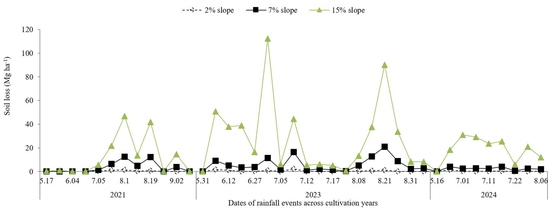
Fig. 5
Soil loss (Mg ha-1) from bare lysimeters at 2%, 7%, and 15% slopes during the 2021, 2023, and 2024 cultivation seasons. The figure shows that soil loss increased sharply with slope gradient, with the 15% slope recording the highest values across all years. Severe soil loss peaks occurred during high-intensity rainfall in 2023, while overall losses were lower in 2024 due to reduced rainfall.
Runoff and soil losses across slope gradients, cultivation types and years
Interannual runoff and soil loss differences
Runoff and soil loss varied substantially across the three years (Table 3). The year 2023 recorded the highest runoff volume (2,282 Mg ha-1) across all lysimeters, followed by 2021 (1,692 Mg ha-1) and then 2024 (852 Mg ha-1). A similar trend was observed for soil loss, with 2023 recording the most severe loss (112 Mg ha-1), compared to 36 Mg ha-1 in 2021 and 27 Mg ha-1 in 2024. These interannual differences may be attributed to variations in rainfall intensity and soil moisture conditions. Highest total rainfall amount and intensity (Fig. 1) received in 2023 contributed to the elevated cumulative runoff and soil loss values, as intense precipitation events can enhance surface sealing, reduce infiltration and accelerate erosion (Wischmeier and Smith, 1978; Nearing et al., 2005).
Table 3
Average runoff volumes and total soil loss across years, cultivation type and slope on rainfall events.
Impact of cultivation type on runoff and soil loss
Cultivation type (bare lysimeters and conventional potato) influenced runoff and erosion dynamics. Bare lysimeters recorded much higher runoff volumes (2,224 Mg ha-1) and soil loss (108 Mg ha-1) compared to conventional potato lysimeters which recorded runoff volume of 993 Mg ha-1 and soil loss of 9 Mg ha-1 (Table 3). The presence of vegetative cover in conventional potato lysimeters contributed to the reduction in both runoff and sediment detachment. Vegetation intercepts rainfall, reduces raindrop impact and promotes infiltration, all of which are critical in reducing soil erosion (Gyssels et al., 2005; Morgan, 2005). This finding demonstrates the importance of vegetation in mitigating soil erosion and managing water loss, even under conventional agricultural practices.
Effect of slope on runoff and soil loss
The slopes of the lysimeters had varying effects on both runoff and erosion. The 7% slope lysimeter recorded the highest runoff volume across the years and cultivation types (1,710 Mg ha-1), followed by 2% slope (1,577 Mg ha-1) and then 15% slope (1,537 Mg ha-1) (Table 3). The unexpected lower runoff volumes on the 15% slope compared to 7% slope suggests more complex interactions between infiltration rates, slope lengths and potential runoff pathways. This finding suggests that runoff may not always increase linearly with slope gradient, but may be influenced by a combination of other factors such as rainfall characteristics, runoff energy and flow velocity and intrinsic soil physical properties (Kinnell, 2010; Li et al., 2017). Thus both slope gradient and soil management must be carefully considered when designing erosion control strategies. Soil loss was highest at the 15% slope with 140 Mg ha-1, followed by the 7% slope (30 Mg ha-1) and then 2% slope (4 Mg ha-1). The highest soil loss on the 15% slope is consistent with the well-established positive relationship between a certain range of slope gradient and soil erosion (Zhang et al., 2004).
Cover management factor of conventionally cultivated potato
The C-factor, an indicator of the effectiveness of the vegetation cover in reducing soil losses relative to bare soil, varied substantially across slope gradients and growing seasons. Generally, the results showed that conventionally cultivated potato lysimeters experienced considerable soil loss, particularly on steeper slopes, but still offered some erosion control compared to bare soil (Table 4). In the 2021 growing season (May 17 to September 8), total soil loss from potato lysimeters ranged from 3 Mg ha-1 at a 7% slope to 15 Mg ha-1 at 15% slope (Table 4). Corresponding losses on bare lysimeters were higher, especially at 15% slope (146 Mg ha-1), leading to C-factor values of 0.76, 0.07 and 0.1 at 2, 7 and 15% slopes respectively (Table 4). The high C-factor at the 2% slope suggests minimal differences in soil loss between potato-covered and bare soil lysimeters at low slope gradients, likely due to inherently low erosion potential on an almost flat terrain (Morgan, 2005). However, the extreme increases in soil loss in the bare lysimeters at steeper slopes (Table 4; 4 - 146 Mg ha-1) indicate the increasing importance of vegetative cover in mitigating soil loss under high erosive forces (Lal, 1998). In the 2023 growing season (May 13 to September, 18), a similar pattern was observed. While soil loss from potato lysimeters increased slightly, compared to 2021 (Table 4), soil losses in bare lysimeters rose disproportionately (9 - 516 Mg ha-1), producing lower C-factors of 0.33 at 2% slope, 0.06 at 7% slope and 0.06 at 15% slope. This result is attributed to the relatively more intensive rainfall received in the 2023 growing season (Fig. 1) compared to other years. The result reaffirms the role of slope gradient and intensive rainfall in amplifying erosion under bare soil conditions, and demonstrates the effectiveness of even sparse vegetation cover, like that of potato, in reducing soil loss on steep terrains and under such intensive rainfall events (Panagos et al., 2015). The 2024 growing season with the shortest observation window (May 16 to August 06), showed the lowest soil losses per slope. At 2%, 7% and 15% slopes, potato lysimeter soil losses were only 1, 4 and 11 Mg ha-1, with C-factors of 0.40, 0.17 and 0.07 respectively. Across all years, the general trend was a decrease in C-factor with increasing slope, which can be attributed to the non-linear increases in soil loss from the bare lysimeters, with increasing gradients. Despite large soil losses in potato lysimeters, the much greater losses in bare lysimeters resulted in the lower C-factors at 7 and 15% slopes across the years. Averaged across slope gradients and years, conventionally cultivated potato had a C-factor of 0.22 during the potato growing season. If extrapolated for a full year, including the non-cultivation period, this value would be higher, as substantial soil loss occurs after harvest. In comparison, conventionally cultivated highland Kimchi cabbage in Gangwon had a C-factor of 0.13 during its growing season, averaged across slope gradients and years in 2021 and 2022 (Kim et al., 2023). Historical data from 1977 to 2001 reported annual C-factors, including non-cultivation periods, of 0.59 for Kimchi cabbage, 0.44 for maize, and 0.19 for soybean under conventional management (Jung et al., 2004). The relatively high C-factor for Kimchi cabbage reflects its short cultivation period and the absence of cropping during the rainy seasons, in their studies. Canopy density and coverage rate and duration appear to play critical roles in soil loss control (Suwanmanon and Kim, 2021), as soybean’s faster growth and denser canopy provide more effective soil protection compared to the other crops mentioned.
Table 4
Cover management factors of slope gradients in the growing seasons.
Conclusion
This study assessed the extent and primary drivers of soil loss under conventional potato cultivation in highland agricultural systems of Gangwon Province, with a focus on the role of vegetative cover through cover management factor (C-factor) analysis. The findings confirm the hypothesis that conventionally tilled potato fields are susceptible to soil erosion, especially under fine soil textures, intense rainfall, and steep slope conditions, although the extent of soil loss varied considerably with slope gradient and rainfall intensity. While the findings provide valuable insights into the factors influencing soil loss in conventional potato cultivation, the lack of replication in this study remains a limitation that may have influenced the strength and generalizability of the conclusions.
Runoff was primarily driven by rainfall amount and intensity rather than slope gradient, as shown by the weak correlations between slope and runoff volumes and stronger relationships with rainfall characteristics. This indicates that in highland agriculture, where precipitation events are intense and episodic, rainfall is the dominant factor influencing hydrological responses. However, soil loss patterns showed a stronger dependency on slope gradient, with the steepest slopes (15%) consistently recording the highest erosion levels across years, affirming the role of slope gradients in accelerating soil detachment and transport under disturbed soil conditions.
The study also demonstrated the critical protective role of vegetative cover, even under conventional tillage systems. Conventional potato cultivation reduced runoff and soil loss substantially, relative to bare soil. Cover management factor values ranged widely across slope gradients and years generally declining with increasing slope which indicates that vegetation is increasingly important in mitigating erosion on steeper terrains. The relatively high C-factors at low slope gradients further indicate that in flatter areas, potato canopy cover may offer limited additional protection over bare soil due to the already low erosion risk.
These findings highlight the vulnerability of conventional potato farming systems to soil degradation and suggest that additional erosion control measures such as mulching, contour farming, or integrating cover crops, are necessary to sustainably manage soil resources in the highlands. The study reinforces the value of slope-specific and rainfall-responsive land management strategies to reduce erosion risks and improve long-term soil conservation in mountainous agricultural regions. To strengthen the robustness and general applicability of the results, future studies should include sufficient replications across treatments.
