

Introduction
Among the extensive tidal flats spread along the western coast of Korea Korean government and private companies have reclaimed approximately 156,600 ha of tidal flat land for the mainly paddy field in Korea since 1945 constantly searching for additional farmland to secure the agricultural land for food deficit of staple crops as well as for industrial demand, port facilities and other urban uses for several hundred years in small scales (Kim, 1988; Hwang, 1999). A large scale reclamation was started in the west coast of Korea after the Korean government set up the policy of designated absolute agricultural land throughout the country in 1984. Most of the reclaimed tidal flat lands (RTFL) have been used as a paddy to grow a rice. In the recent years, the need for the RTFL to cultivate a rice as the staple crop has been decreased due to the excess yield and the additional amount of rice imported as agreed on FTA in accordance with the rapid reduction of the annual rice consumption per capita from 135 the kg in 1980s to less than 68 kg in 2017. Therefore, the government has strongly pursued the policy to convert the paddy field into upland although there are many difficulties in growing crops due to inherent extremely poor soil physical and chemical properties and extremely low permeability and low fertility in addition to salinity due to easy accumulation of salts on the soil surface by capillary rise in utilizing the tidal flats as arable land (RDA, 2016; Oh et al., 2016). Therefore, site-specific reclamation methods are of broad scientific interest. The most of the researches related to the reclaimed tidal soil mainly focused on desalinization that could be the limiting factor in crop growth and soil water management (Chung et al., 2012).
RTFL on the west coast of the Korean peninsula, that is fronted by both extensive sand flats and mudflats, have formed in a high-tide-range environment and are generally backed by rugged headlands and conical hills. A tidal flat soil consists of sandy or muddy sediments which are brought by the deposition processes of weathering minerals throughout the processes of erosion, transport, deposition and consolidation cycle. Therefore, kaolinite and quartz formed from residual weathering processes in acid condition can be then transported and deposited in the marine environment (Ismail, 1970; Supiandi and Sumawinata, 1989; Black et al., 2002). Acid sulfate soils (ACS) caused by iron sulfide mineral pyrite as the dominant mineral primarily created issues in coastal regions when exposed to oxidizing conditions in low-lying coastal areas, back swamps and in estuarine environments, particularly those water-logging areas affected by fluctuating water tables between the periods of ebb and tide. Unfortunately, drainage of acid sulfate soils for agricultural development can create the acidification process, with dire consequences for farmland productivity and waterway health (van Breeman, 1973; Park et al., 1991; Park et al., 1998; Lee et al., 1994; Ahern et al., 1998; Hey and Ahern, 2000; Hey et al., 2000; McElnea et al., 2002; Jayalath, 2012). Actual acid sulfate soils have already undergone oxidation to produce acid, resulting in a soil field pH of less than 4. But they have the potential to produce more acid if these soils still contain sulfides (Kim, 1980; Choi, 1981; Park and Khim, 1990; Park and Choi, 1998; Moon et al., 2000; Ryu et al., 2002; CSIRO, 2003; WADE, 2006). The pale yellow (2.5-5Y 8/3-8/6) jarosite [KFe3(OH)6(SO4)2] is conspicuous in most acid sulfate soils. It commonly occurs as earthy fillings of void or as mottles in the soil matrix. The pale yellow mottles are so characteristic that they are used, together with pH, as a diagnostic criterion for classifying acid sulfate soils (USDA, 1975). However, relatively few studies have focused on soil physical and chemical properties including types of clay minerals which are important information in developing reclamation methods for tidal flat soils, especially as upland soils.
The purpose of this investigation is to identify the clay mineralogical composition and soil chemical properties of the newly reclaimed tidal flat soils to design site-specific methods for improving the physical and chemical properties of soils because there are many inherent difficulties such as acidic surface horizons as well as extremely low permeability and saline-sodic problems.
Materials and Methods
Study area
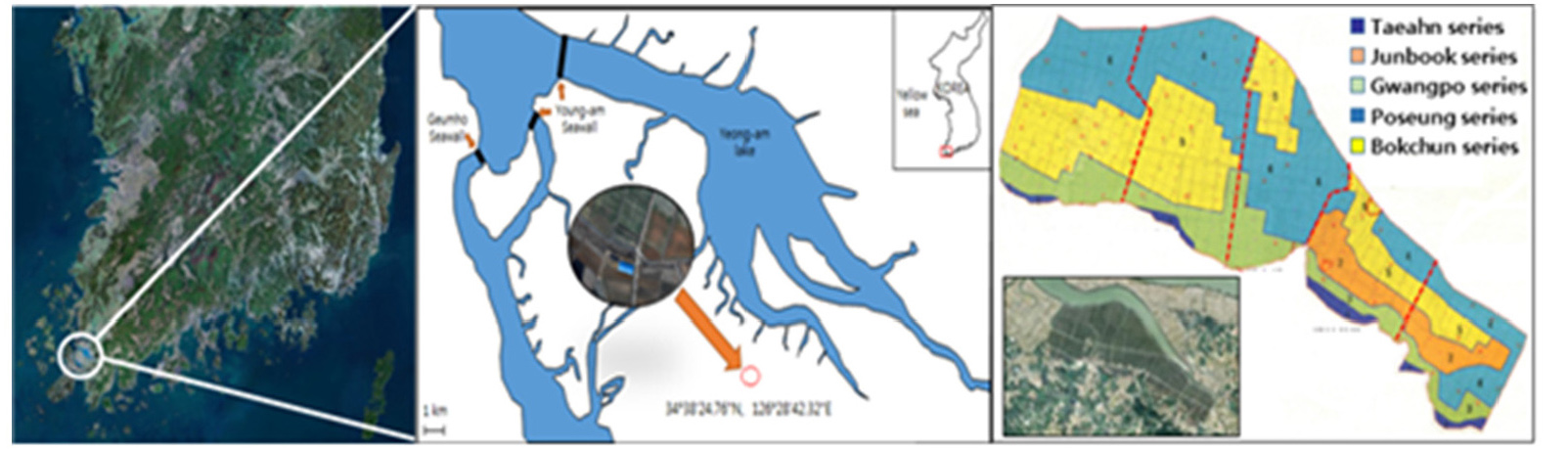
The RTFL which was selected as an experimental site within the Haenam bay with average widths of about 2 - 2.5 km was constructed in 2009 and partially shared with acid sulfate soil within the RTFL, that is a typical ria-type coastal embayment of semi-enclosed and gourd-shaped narrow baymouth in the south-western coast of Korea (Fig. 1). Most of the tidal flats are now completely exposed. The main tidal channel (up to 20 m deep and 4.5 km wide) flows northwest-southeast along the center of the bay. On two sides of the bay, there are 1- to 3-km-wide intertidal flats, composed mostly of muddy sediments and dissected by dendritic tidal creeks. There are no salt marshes, barrier islands, or major river drainage systems in the bay, so that input of sediments is meager. The geology of Haenam Bay shows largely Mesozoic sedimentary and volcanic rocks, local metamorphic rocks, and late Quaternary sediments on the coastal plain (Lim et al., 2003). The RTFS of Haenam Bay are classified into five different soil series of Taeahn (TH), Junbook (JB), Gwangpo (GP), Poseung (PS), and Bokchun (BC) (RDA, 2017) and is composed largely of Mesozoic sedimentary and volcanic rocks, local metamorphic rocks, and Late Quaternary sediments on the coastal plain (Park et al., 1995).
Fig. 1.
Index map and Locations of soil profile investigation pits and soil sampling points for five soil series within the experimental site at the RTFS within the Haenam Bay. Numerous dendritic streams on the wide tidal flat and main tidal channel (maximum depth of 25 m) comprise the coastal embayment.
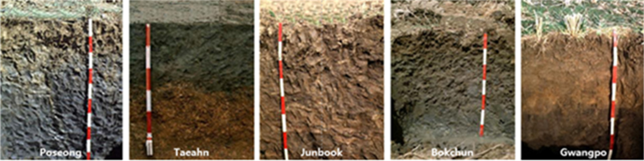
The complete soil profile descriptions were recorded for the selected two typical pits of five soil series within the experimental site in accordance with the procedures of the Soil Survey Manual (Soil Survey Division Staff, 1999). For the laboratory analysis of the clay mineralogical composition and physical and chemical characteristics of every identifiable horizon within the soil profile, triplicate undisturbed soil samples using a 5 cm in diameter and 10 cm long gouge-auger with plastic liner were also taken (Fig. 2).
A representative portion of each soil sample was removed and dispersed in distilled water using a reciprocal shaker by treatment with ultrasound. The suspension was then sieved on 63 µm, and the material that had passed through the sieve was then placed in a measuring cylinder and allowed to stand. In order to prevent flocculation of the clay crystals, 2 mL of 0.1 M sodium hexametaphosphate was added to each suspension. After a period dictated by Stoke's Law, a nominal < 2 µm was then re-suspended in a minimum of distilled water and pipette onto a ceramic tile in a vacuum apparatus to produce an oriented mount.
The XRD analysis was conducted using a X-ray diffractometer (Rigaku DMAX-2500, Japan) equipped with a CuKa-radiation source for homogeneous and well ground soil particles before and after heating and for magnesium-saturated (Mg-clay) with or without glycation (Reynolds, 1989). Also, the air-dried soil samples were characterized by emission scanning electron microscopy (ESEM) equipped with energy dispersive spectroscopy (EDS) and back-scattered electron detector (BED) directly revealing the presence of the atomic elements in the sample (Gilkes et al., 1980). To do this the soil samples were embedded inside an epoxy resin and then coated with 3 nm of Os prior to the SEM observation.
To analyze the chemical properties of the soil samples, the soil samples were air-dried and ground to pass 2 mm sieve using Wiley mill. Soil texture was analyzed by hydrometer method, pH and EC of soils were measured in 1:5 soil to deionized water ratio and 1N KCl. Cation exchange capacity (CEC) and organic matter content (OM) were determined by the ammonium acetate exchange method and Walkley- Blacks procedure, respectively. The exchangeable acid cations (Al and H) were obtained by titration with 1.0 M KCl extract. The exchangeable basic cations extracted with sequential washing with ethanol and 1.0 M ammonium acetate solution were determined by inductively coupled plasma (ICP-OES Agilent Technology 720, USA). All measurements were repeated in triplicate. The results are summarized in Table 1.
Table 1. The description of soil profiles for the soil series found in the investigation site within Haenam Bay.
Results and Discussion
Characteristics of soil series
For the characteristics of soil series found in the investigation site as shown in Table 1, the TH soil series (Coarse loamy, mixed, mesic family of Aquic Udorthents) which have a shallow surface horizon contains two typical Ap (0 - 27 cm) and C (27 - 120 cm) horizons. The Ap horizon is divided into Ap1 (0 - 8 cm) and Ap2 (8 - 27 cm). There is the relatively sharp boundary between Ap and C; the soil textures of Ap1 and Ap2 are silty loams with dark gray gravel along with small quartz particles and slightly dark brown mottles (7.5YR 5/6) and C is loam with small dark yellow brown granite gravel and mica. The soil colors of Ap1 and Ap2 are strong gray (5Y 4/1) and gray (2.5Y 5/1) while the colors of C are mixed with dark brown (10YR 6/4) and light brown (10YR 7/3). The soil structures of Ap1, Ap2, and C are massive, platy, and structureless, respectively. The BC soil series (fine, silty mixed, nonacid, mesic family of Typic Haplaquepts) contains five horizons of Ap (0 - 15 cm), B1g (15 - 30 cm), B2g (30 - 65 cm), C1g (65 - 90 cm) and C2g (90 - 110 cm). The soil textures are silty loams for all horizons. The structure of surface soil (Ap) and subsurface (B1g) are structureless with mottles (5YR 5/8 for Ap and 10YR 4/4 for B1g). Soil colors are dark gray (5Y 3/1), very dark gray (5Y 3/1), gray ( 5Y 5/1), olive gray (5Y 5/2) and bluish gray (10 GB 5/1) for Ap, B1g, B2g, C1g and C2g, respectively. The JB soil series (fine silty, mixed, nonacid, mesic family of Aeric Fluventic Haplaquepts) contains six horizons of Ap1g (0 - 10 cm), Ap2g (10 - 19 cm), B1g (19 - 27 cm), B2g (27 - 85 cm), B3g (85 - 120 cm), and Cg (120 - 160 cm), and shows slightly deeper soil depth compared with other soil series found in the investigation site. Soil textures are silty loams for all horizons except B2g which is silty clay loam. The structure of surface soil (Ap horizon) with gray or dark grayish brown while subsurface (B1g) are structureless with mottles (5YR 5/8 for Ap and 10YR 4/4 for B1g). Soil colors are dark gray (5Y 3/1), very dark gray (5Y 3/1), gray (5Y 5/1), olive gray (5Y 5/2) and bluish gray (10 GB 5/1) for Ap, B1g, B2g, C1g and C2g, respectively. GP soil series (coarse loamy, mixed, nonacid, mesic family of Fluventic Haplaquepts) contains five horizons of Ap (0 - 12 cm), B1g (12 - 24 cm), B2g (24 - 39 cm), B3g (39 - 60 cm), and Cg (60 - 120 cm). Soil textures are silty loams for all horizons with dark gray colors except Ap horizon which is dark yellow brown. The structures of subsurface soil for B horizons are large blocky and large angular with yellow red and dark red mottles at B1 and B21g. Soil colors become darker from the soil surface (10YR 4/4) to stratum (5Y 4/1). PS soil series (fine silty, mixed, nonacid, mesic family of Typic Haplaquents) contains six horizons of Ap (0 - 12 cm), B1g (12 - 20 cm), B21g (20 - 32 cm), B22g (32 - 56 cm), B22g (56 - 91 cm), and Cg (91 - 140 cm). Soil textures are loam, silty clay loams, silty loams from surface to stratum with mottles for Ap, B1g, and B2g, the soil structures are large structure besides B22g as of small blocky.
For the soil properties identified from the soil horizons of each soil series on the investigation site as seen in Table 2, the relatively very low sand contents are noticeable features of the BC and JB soil series while the clay contents of the TH and GP soil series are relatively low compared with those of the JB and PS soil series. The pH values of the soil horizons for the soil series varied considerably, with somewhat more acid in Ap horizons showing dark brown or yellow mottles than those of subsurface horizons for the BC, JB, and PS soil series with relatively higher clay content than other soil series on the investigation site. The organic matter contents lower than 1% or low pH than 5 significantly influenced the cation exchange capacity of the soil horizons of each soil series. Also, the base saturations (BS) correspond to the soil pH regardless of organic matter contents, indicating that the BS is increased with increasing soil pH.
Table 2. The description of soil profiles for the soil series found in the investigation site within Haenam Bay.
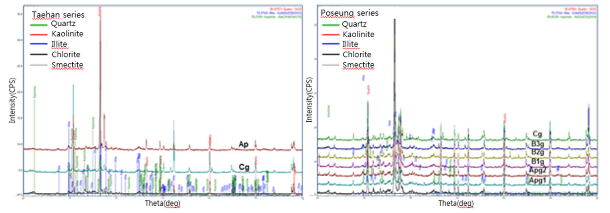
As observed in Table 1, the soils of the Ap horizons of the soil series on the investigation site have the different soil chemical properties. Eswaran and Bin (1978) pointed out that conditions may have differed at different stages of soil development in soil profiles, leading to reflection of changing conditions rather than a mineral-alteration sequence. The soils from Ap and Bg horizons of JB, BC and PS soil series have the yellow mottles and pHs of them are less than 4.5 while the sand contents in soils of TH and GP soil series are much higher than those of JB, BC and PS and clay contents are less than 11%. X-ray diffraction (XRD) analyses of specimens of the Ap horizons for the GP, JB, GP and PS soil series are presented in Fig. 3. The results of XRD show that the major minerals of the JB, BC and PS soil series are quartz, illite, smectite and kaolinite whereas those of the GP and TH soil series are quartz and illite. Especially, the contents of smectite and kaolinite in the GP soil series are relatively very small (Fig. 3). From these results, we figure out that soil particle distribution influences the presence of kaolinite in Ap horizon, as well as pH of the Ap horizon. The presence of quartz in the clay fraction supports the deduction that the parent material is originated from weathering of acid rocks. However, it is difficult to distinguish whether kaolinite in each horizon was formed from weathering of smectite or from sedimentation processes.
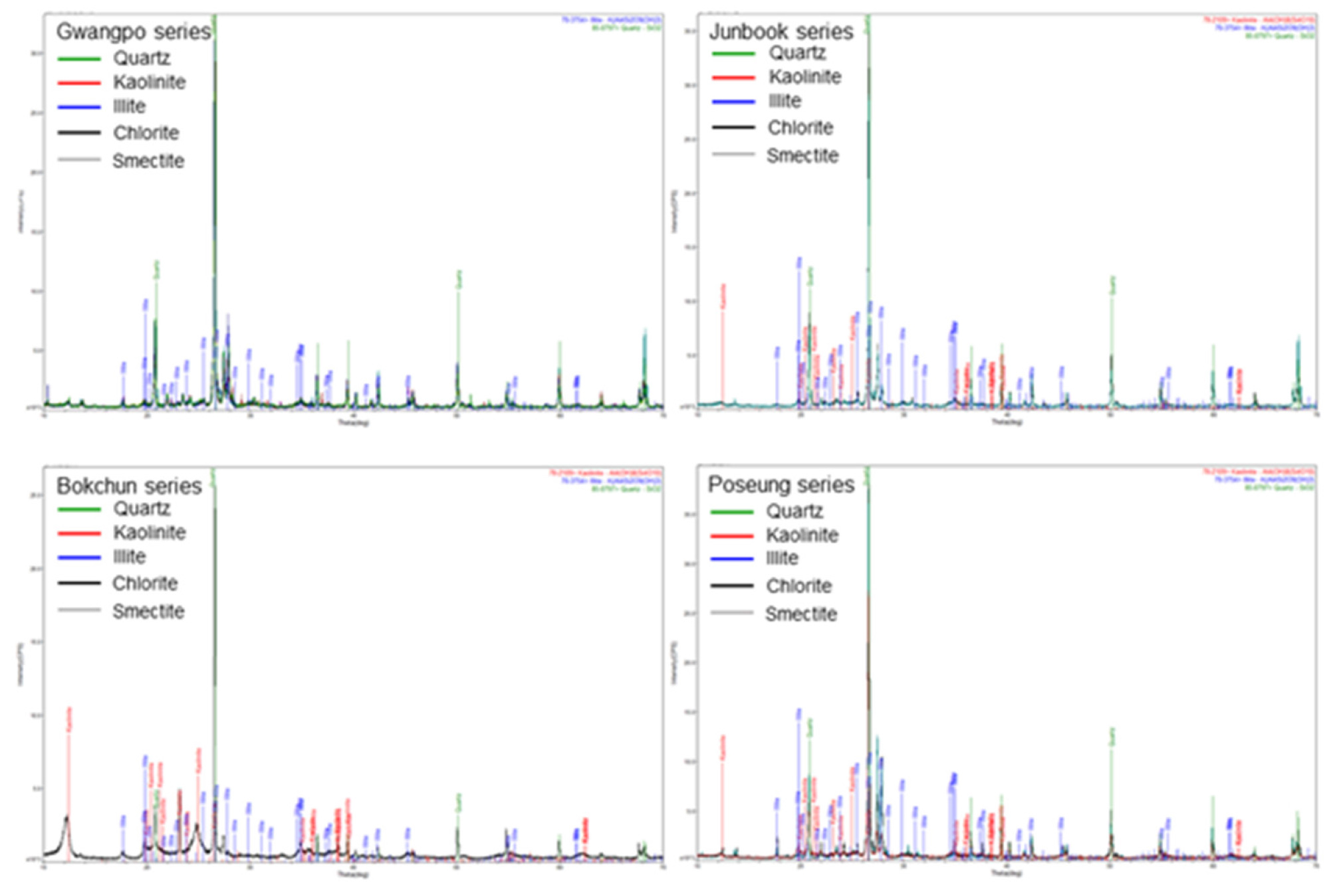
Eswaran and Bin (1978) also pointed out that in thick soil profiles conditions may have differed at different stages of soil development. Thus, the present-day occurrence of minerals in a soil profile may reflect these changing conditions rather than a mineral-alteration sequence. Fig. 4 illustrates representative XRD patterns for the clay-size fractions from Ap to Cg horizon in the TH and PS soil series. The main clay mineral assemblages from Ap to Cg horizon are quartz (SiO2), illite [K(Al4Si2O9(OH)3), and kaolinite [Al4(OH)8(SiO10)], chlorite [(Mg,Fe)3(Si,Al)4O10], smectite [A0.3D2-3(T4O10)Z2․nH2O] although there are slight differences in the relative amounts of clay minerals between two soil series. Also the XRD patterns depending on the properties of soil series between two soil series show the high intensity and broad peaks of silica in the form of quartz of which the peaks of quartz overlap with the peaks of illite. Illite in all depths of the PS soil series forms the largest component of the clay fraction mixed with small to moderate amounts of kaolinite whereas the TH soil series is characterized by the lack of smectite and slightly higher kaolinite contents.
SEM-EDS
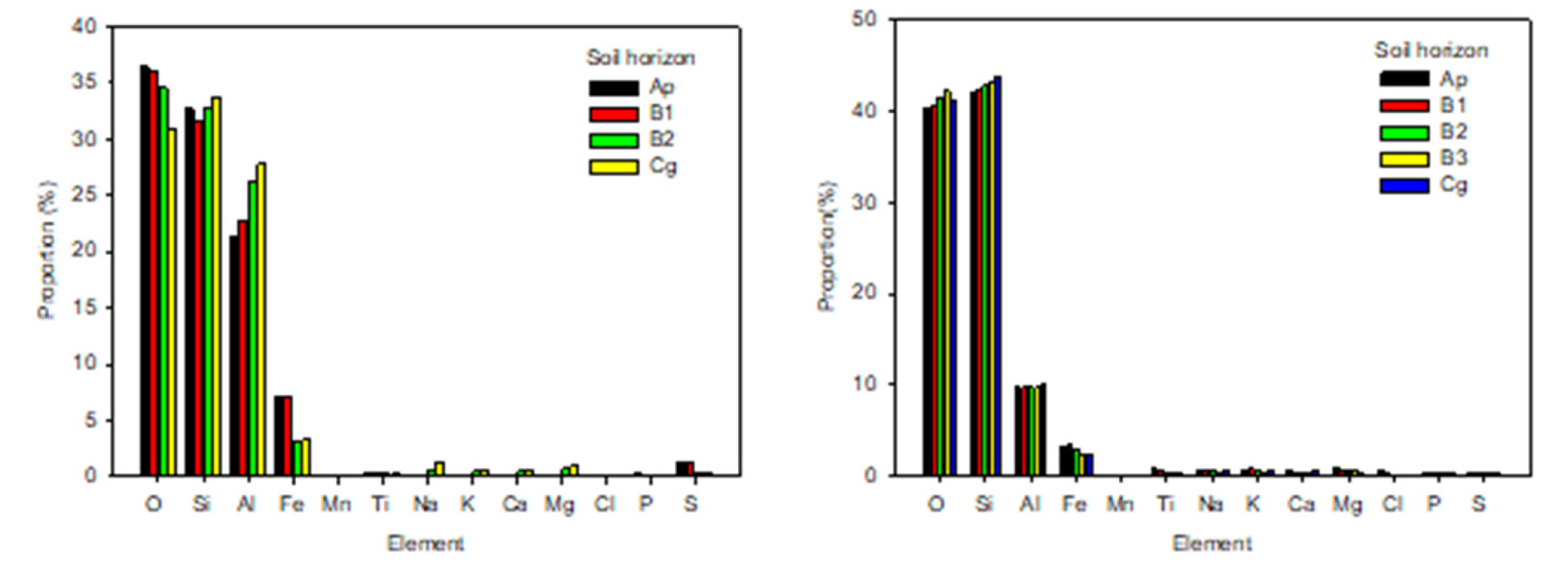
The analyses of soil samples obtained from the Ap horizons of the five soil series using Energy Dispersion Spectroscopy (EDS) spectrum and Scanning Electron Microscope (SEM) micrograph are presented in Table 3. The main clay minerals in the five soil series are illite, kaolinite, chlorite, smectite and quartz grains as seen in Fig. 3. The pHs of Ap and Bg horizons of BC, JB and PS are less than 4.5 and the clay contents of them are higher than those of the Ap and Bg horizons of TH and GP of which pHs are neutral or higher. The elements analyzed by SEM-EDS for the soils of the Ap and Bg horizons of the five soil series are C, Si, O, Al, K, Na, Ca, Mg, Cl, Fe, Ti, P, S and Mn (Table 3). Among these elements, silica and aluminum primarily associated with silicate clay minerals are dominant for the soils of the Ap and Bg horizons and the aluminum contents of the Ap and Bg horizons for BC, JB and PS soil series are much higher than those of the TH and GP soil series although the contents of Si and O contents of them are slightly lower than those of TH and GP. In addition to this, the contents of Fe and S for BC, JB and PS soil series are much higher than those of TH and GP, resulting in that the soil color is slightly pale yellow to yellow. The amounts of base cations such as Na, K, Ca and Mg in the Ap and Bg horizons for the BC, JB and PS are lower than those of the Ap and Bg horizons for TH and GP of which pHs are above 7. Therefore, Ca and K can be deficient in acidic soil conditions. For this result we assume that pH less than 4.5 and removal of bases as sulfate may influence the amounts of the bases as well as most of the exchange complex is occupied by aluminum as reported by Attanandana and Vacharotayan (1986). From these element compositions and contents of the BC, JB and PS soil series, we can assume that the acidic conditions of the Ap and Bg horizons are caused by the presence of the hydrolyzable aluminum and the fine-grained pyrite typical of tidal sediments.
Table 3. The analyses of major and minor element compositions of soil samples using Energy Dispersion Spectroscopy (EDS) spectrum and Scanning Electron Microscope (SEM) micrograph for the Ap and Bg horizons of the five soil series on the investigation site.
Using SEM-EDS we compare the element composition of soils from Ap to Cg horizons for two soil series of GP and PS having different soil particle distributions and chemical properties (Fig. 5). The elements in soils from Ap horizon of the GP and PS are very similar although the major minerals of the PS are quartz, illite, smectite and kaolinite whereas the those of the GP are quartz and illite. The element compositions are in the order of O > Si > Al > Fe while the amounts of Al and Fe in PS are at least twist as much as those of GP. Especially, the proportion of Fe in PS is distinctive in Ap and B1 of which pHs are acidic whereas the amounts of Fe in GP are not much different from Ap to Cg horizon. From this result, we can figure out that the types of clay mineral and pH of soil horizon influence the presence of elements in soils.
The element distribution and morphology of the soil samples of Ap horizon for TH, GP, JB and PS soil series using SEM-EDS are presented in Fig. 6. Gilkes et al., (1980) presumed that broad trends in morphology of soils with depth could illustrate the transport and accumulation of different weathering clay minerals. SEM examination of soils reveal a large variety of morphologies because of various mixtures of quartz, kaolinite, illite and smectite. The element distribution and morphology show that the TH and GP of which the content of sand is significantly higher and the content of clay is much lower than those JB and PS contain O and Si as major constituents, Al and K as minor constituents along with small amounts of Fe and other bases such as Na, Mg, Ca. But JB and PS contain O, Si and Al as major constituents, K and Fe as minor constituents along with small amounts of P, S, Ti and other bases such as Na, Mg, Ca. Panno et al. (2000) reported that presence of Cl could be related to rock-water interactions. Especially, line scan indicates presence of chloride in TH and GP.
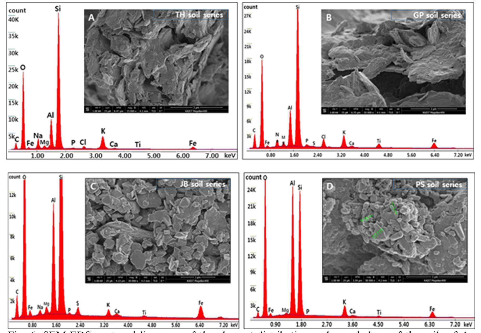
Compared the SEM images of JB and PS containing high clay content in acidic condition with TH and GP containing very high sand content with neutral or higher pH, the results of SEM analyses clearly indicate intermixing of Fe and Al-Si mineral phases and the SEM images of JB and PS reveal a large variety of morphologies and kaolinite particles of varying sizes are arranged in face-to-face patterns along with the presence of spherical particles of quartz (Fig. 6C and D). Generally, kaolinite occurs as aggregates of platy crystals about 0.1 p.m. in size and kaolinitic platelets are clearly visible in a nonmagnetic fraction (Eswaran and Bin, 1978). Sengupta et al., (2008) described that rounded nature of quartz particles and spherical grains indicate sediment accumulation.
Conclusion
The results of soil profile description for the five soil series on the investigation site show that most of the noticeable soil textures are sandy loams for TH and GP and silt loams for BC, JB and PS, and that soil colors of the Ap and Bg horizon with mottles of various colors such as olive brown (2.5Y 4/4), reddish brown (5YR 5/8), brown (7.5YR 4/4), and dark grayish brown (10YR 4/2) are strong brown to dark yellowish brown for TH and GP and dark olive gray to gray for BC, JB and PS although no pyrite was found in the soil profile by chemical or XRD methods. The pH by H2O for the surface horizons of BC, JB, and PS soil series is less than 4.5 while the pHs of TH and GP with higher sand contents than those of BC, JB, and PS is 6.5 or higher. The analyses of XRD represent that the major minerals of the JB, BC and PS are quartz, illite, smectite, and kaolinite whereas those of the GP and TH are only quartz and illite. Among the major elements observed by ESEM-EDS, aluminum content primarily associated with silicon as the components of clay minerals is higher in BC, JB, and PS of which clay contents are much higher than those in TH and GP. From this, we can assume that the types and contents of clay minerals influences soil pH and presence of aluminum in Ap and Bg horizons of BC, JB, and PS. SEM analyses indicate intermixing of Fe and Al-Si mineral phases and JB and PS reveal a large variety of morphologies and kaolinite particles of varying sizes are arranged in face-to-face patterns along with the presence of spherical particles of quartz.
